Terrace Concept General Considerations
The construction and use of a network of graded terraces for ice sheet melt water collection is an essential element of this project concept. Agricultural graded terraces are widely used for erosion control on sloped fields. Many of the design considerations used for agricultural terraces apply for this application. [3]
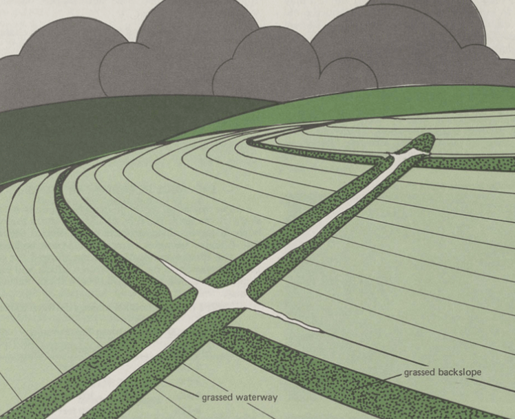
Illustration of agricultural graded terraces along a sloped field
The technique that will be utilized to collect the melt water is to excavate a network of graded terraces that will form channels that carry the melt water from the far reaches of the collection area using gravity flow to the edge of the impounded lake. Each terrace will be constructed to provide for a controlled flow of melt water from the areas that are most distant from Tasersiaq Lake and continuing along a uniform gentle slope toward the lake where each terrace will terminate. The channels will be widely spaced so that each channel will collect runoff from a large area of ice sheet surface that naturally drains from elevations above the channel. The cross-sectional size of each terrace channel, its gradient, which determines stream flow rate, and its spacing with respect to adjacent terraces, which determines its collection area, will be selected to optimize the collection efficiency of the terrace network.
Construction and maintenance of the melt water collection channels represents a major undertaking. This large-scale glacial terracing project will be the first of its type. Therefore, a proof-of-concept demonstration of this approach will be required prior to launch of the overall construction project. Terrace construction will be carried out while the other major elements of the hydro project are under construction.
An examination of a topographic map of the Greenland ice sheet shows that the topography of the ice sheet east of Tasersiaq Lake is ideal for the construction of a network of terraces that drain into the Tasersiaq Lake catchment. [4] The elevation of the ice sheet rises in a nearly uniform fashion from near the western edge of the ice sheet to a ridge near the center of the island 220 km to the east. The elevation gradient is nearly flat along the north-south axis of the terraced catchment. The map shows no obvious large obstructions and a relatively uniform gentle slope that lends itself well to the construction of graded terraces.
Runoff from the southwestern region of the Greenland ice sheet has been estimated by Brice Noël et al. [5] Figure 1 of that report shows that the runoff is concentrated in a band that extends along the western edge of the ice sheet up to an elevation near the edge of the ablation zone at 1550 m elevation. Figure 1 chart C estimates that current average runoff in the SW Greenland area, based on the linear runoff trend line, totals approximately 125 km^3 per year. The length of the ice sheet margin in the SW region is approximately 850 km.
One estimate of natural Tasersiaq Lake ice sheet runoff has been reported by Ahlstrøm et al. [6] Figure 3 of that article shows annual ice sheet runoff from the Tasersiaq catchment based upon river flow measurements at the lake outlet over the period from 1975 through 2015. The chart shows that the average runoff has increased over the most recent 10 years of recorded runoffs. During the period from 2003 through 2014 the average runoff has averaged 3.6 km^3/year. Figure 1 of the report shows the natural Tasersiaq Lake ice sheet catchment. It is an average of about 35 km wide in the region from the east end of the lake to the ablation line at an elevation of 1550 m.
Terrace Concept for 680 MW project
A relatively small terracing project is required to collect water for the 680 MW project. A network of 15 channels each with an average length of 20 km will be sufficient to collect the additional required melt water for the 680 MW project. This makes the overall length of the required channels less than 2% that of the network of channels needed for the 2,250 MW project. This dramatic difference in terrace network size can be explained when one considers that the 680 MW project requires a terrace network that collects only approximately 10% as much water beyond the natural catchment as the 2250 MW project. The collection area is also, on average, only 10 km away from the natural catchment for the 680 MW project versus, on average, approximately 60 km for the 2250 MW project.
Terrace Concept for 2250 MW project
A vastly larger terracing project is required to satisfy the needs for a 2250 MW project. The current plan, for the 2,250 MW project, is to extend the terrace network from the lake north to a point 140 km north of the lake. The network will extend south from the lake to a point 105 km south of the lake. This is a north-south distance of 245 km. The first terraces, having minimum elevation east of the lake, will begin at an elevation of 1050 m. The slope of the channel will increase the channel elevation by 1.25 m/km of distance from the lake. Based on that terrace network configuration it is estimated that 75% of the runoff within the 245 km long collection region occurs within the boundaries of the terrace network.
Using the measured flow reported by Ahlstrøm et al. [6] of 3.6 km^3/year over the 35 km wide natural catchment, it is then estimated that 18.9 km^3/yr of runoff are present and available for collection within the footprint of the terrace network. A somewhat larger amount is estimated if the runoff reported by Noël et al [5] is used. In that case the available runoff is estimated as 27 km^3/ yr.
The current project concept requires that a total of 13.5 km^3/yr of water be collected into Tasersiaq Lake. Therefore, based upon the two estimates, between 50% and 71% of the annual available runoff must be collected by the terrace network.
As reported by Laurence E Smith et al. [7] the ice sheet within the collection area contains numerous moulins into which melt water drains. The water flows through channels at the base of the ice sheet and exits at locations where glaciers terminate, either on land or at the sea edge. There is an ice sheet surface drainage catchment and supraglacial stream associated with each moulin. The terrace system will be constructed to intercept the stream flowing toward the moulin in one or more locations near the moulin entrance and to redirect the flow into the terrace channel in the direction of Tasersiaq Lake.
In some instances, moulins may be plugged with ice sheet ice from the immediate surrounding area, in coordination with terracing. These techniques will cause most of the melt water to be blocked from entering the moulins and thus it will be retained on the ice sheet surface and directed into the terrace channels.
It is unfortunate that water that enters the moulins in the area east of Tasersiaq Lake does not migrate under the glacier at its base toward Tasersiaq Lake. From a careful examination of base topography, it appears that the rock base topography beneath the ice sheet has a downward slope toward the east from a point a few km east of the eastern edge of Tasersiaq lake. [8] So, the ice sheet melt water that drains through moulins in the area east of Tasersiaq Lake will not drain into the lake. Rather it will follow the contours of the base topography toward the east and then move either south or north before again moving west to enter the sea. Therefore, the melt water must be collected on the surface via the terrace channels or be lost.
Appendix A presents a calculation of the required characteristics of each terrace channel and of the entire channel network for the 2250 MW project. North of Tasersiaq Lake a total of 50 terrace channels will extend to a point approximately 140 km north of the lake catchment. South of Tasersiaq Lake a total of 38 terrace channels will extend to a point approximately 105 km south of the lake catchment. Since each channel will follow the contours of the glacial topography the actual length of each channel will be an estimated 180 km in the north section and 140 km in the south section of terraces.
Terrace Network Construction General Considerations
Channel excavation will be planned for a 2-month period in the spring of each year prior to the beginning of the melt season and a 2-month period in the fall after the ice has refrozen. It is estimated that an average of 120 days will be suitable for work on the ice sheet during each year.
Modern agricultural terracing projects often rely on the use of specialized terracing software with geographic positioning systems (GPS) to establish terrace network layouts and to control terracing equipment to maintain accurate grade control. [9] A system of this type will be selected for use on this project.
The actual excavation of each channel will be performed using a bulldozer with an adjustable front blade and an aft ripper, such as the Caterpillar D7E series. [10] It will be operated utilizing GPS controls for proper contour following and grade control. The ripper will be used to break up the glacial ice to a depth of 1.8 m. The blade will be used to remove the broken ice to form a channel with dimensions as described in Appendix A. The broken chunks of ice will be pushed onto the down slope side of the channel. Caterpillar publishes a handbook that is used to estimate the average production of a Cat D7E series bulldozer. [11] The handbook states that the D7E can excavate 950 m^3/hr under ideal conditions. Taking into account handbook adjustments for ripped frozen ground, poor visibility, and job efficiency of 12 hrs operation out of each 16 hr day the estimated production drops to 420 m^3 per hour.
Excavation of each channel will begin at the Tasersiaq Lake end of the channel and will proceed outward from that point along a nearly uniform sloped grade following the terrain contours. Excavation will be performed during a 2-month period in the spring prior to the beginning of the melt season and during a 2-month period in the fall after to ice has refrozen. Operating on solidly frozen ice will provide better traction to the bulldozers. Bulldozers will have special attachments placed on their tracks to enhance traction. These are called lugs, or corks, or ice claws,
Each bulldozer will be operated on a 16 hr. per day 7 day per week basis with stoppages for unplanned maintenance and unacceptably bad weather. It is estimated that 12 hours per day will be devoted to excavation and the remainder to maintenance etc. To execute this schedule, three operators will be assigned to each work crew. Two operators will be on-site at any time with a third having days off.
In addition to the bulldozer, each crew will also have one service vehicle on-site. The service vehicle will be an arctic all-terrain vehicle like the Burlak4X4. [12] It will be configured with a 2000-liter fuel tank. It will also carry coolant, oil, lubricants, and transmission fluid for the dozer and well as a range of service tools. The crew compartment will be configured with bunks, running water, toilet, food storage, Starlink WIFI, first aid kit, fire extinguisher, radio etc. to support a two-man crew for several days. Each operator will work an 8-hour shift while the other rests or relaxes. The third crew member will rotate to the work site relieving one crew member by using a second arctic all-terrain vehicle. One crew member will drive the first arctic all-terrain vehicle back to the service center at Kangerlussuaq. That crew member will be off duty for several days until returning to the work site with more supplies and to relieve the other crew member.
Terrace Network Construction for 680 MW Project
The overall size of the terrace network for the 680 MW project is relatively small. A network of 15 channels each with an average length of 20 km, located adjacent to the natural catchment, will be sufficient to collect the additional required melt water for the 680 MW project. This makes the overall length of the required channels less than 2% that of the network of channels needed for the 2,250 MW project. It is estimated that two 3-man crews will be required to construct this smaller terrace network during the project construction period.
One example of a construction project that took place on the Greenland ice sheet, with some similarities to this terracing project, is the construction of a road across the ice sheet from the edge of the ice sheet near Kangerlussuaq to an auto test facility 150 km from the ice sheet edge. This project utilized construction equipment similar to that proposed for this project. It included a modified Nissan Patrol with 44” wheels for personnel transport, one Cat 966 wheel loader and one Pistenbulli 300 tracked vehicle for construction, and a Cat D6 for snow removal. Construction took place mainly during cold periods when the surface of the ice sheet was frozen. The frozen surface provided better traction for the vehicles than was available in the wetter summer conditions.
Terrace Network Construction for 2250 MW Project
Based upon the assumptions discussed previously, it will require an average of approximately 83 crews each working for 5 construction seasons to complete the excavation of the entire terrace channel network for the 2250 MW Project.
A small number of special purpose vehicles and cranes will be constructed to retrieve equipment that experience failures that disable the units. Approximately five arctic all-terrain vehicles will be configured to provide emergency medical services. Approximately twenty arctic all-terrain vehicles will be configured to provide unscheduled machine repair and maintenance that can be performed on-site.
An equipment storage, repair and logistics facility will be built at Kangerlussuaq which is located approximately 100 km north of Tasersiaq Lake. It has an airfield that was formerly a US airbase. [13] It also has a small ocean port for transport of machinery, fuels, supplies and personnel which is located approximately 10 km southwest of the airport. [14] The logistics depot will be responsible for resupplying vehicles with fuels and food etc. Housing for work crews will also be built at Kangerlussuaq.
There is an existing road from Kangerlussuaq to the east and onto the ice sheet. Safe road routes will be established on the ice sheet using existing satellite crevasse detection systems. [15] Where appropriate, crevasses along the routes will be filled to provide a safe route surface. Vehicles will be equipped with GPS guidance to navigate the planned routes. Where roads cross completed channels, the channel will be widened to form a wide shallow ford that is easy for the equipment to cross.
By utilizing the approach described above it will be possible to perform the entire terracing construction project without establishing permanent facilities on the ice sheet. Surface transportation can be used for all normal operations.
There are many project functions other than actual construction that must also be performed. They include the full range of project activities including management, engineering, information technology, personnel, accounting, procurement, supply, training, maintenance etc. It is estimated that 264 direct construction staff and 452 support staff will be required during the 5-year construction period. While some employees may work remotely, it is estimated that in excess of 480 employees will be resident in Greenland. A more detailed breakdown of staffing levels, facilities required, and equipment required for the construction project is presented in Appendix B.
Terrace Maintenance General Considerations
Maintenance of the terrace channel system will be required on an ongoing basis extending throughout the expected 40-year life of the project. Several types of maintenance issues may develop. However, since this channel network is a new type of construction and is located on an unusual location, a glacial ice sheet, it is impossible to predict with certainty what types and frequencies of maintenance are required to maintain adequate stream flow.
A demonstration project including the construction of several channels and subsequent attempts at periodic maintenance will be required to determine best practices. This proof of concept must be successfully demonstrated prior to go-ahead for the full hydroelectric project.
During cold periods, snow will fall and drift into the channels. Since packed snow has a density that is only 1/3 that of liquid water, it is not likely that snow will block the flow of water through the channels when melting later occurs. Rather, the snow will float on top of the melt water. One low-cost approach is to allow any snow that accumulates in the channels over the winter to melt naturally. Natural streams on the ice sheet reestablish their flow patterns from year to year in this way.
Erosion of the ice channels during the summer melt is likely to require annual repairs. Maintenance crews will perform terrace channel repairs primarily during a 2-month period in the fall after the ice sheet has refrozen and during a 2-month period in the spring prior to the beginning of the melt season. Tracked excavators like to Caterpillar 320 GC Tracked Excavator will be used. [16] The Caterpillar Performance Handbook [10] states that the 320GC can excavate 210 m^3/hr under ideal conditions. Adjusting for hard rock like material, availability, and efficiency, it is estimated that each 320 GC will be able to excavate approximately 120 m^3/hr in ice sheet conditions. As with the bulldozers, ice lugs, corks, or ice claws will be affixed to the tracks to improve traction. Working on frozen ice in the spring and fall will also provide superior traction compared to the conditions during the melt season.
The technique used for support of the excavators will be similar to the approach used for the construction crews. In addition to the excavator, each crew will also have one all-terrain service vehicle on-site. Crew members will rotate to and from the work sites using service vehicles. A detailed description of the construction support approach of the terrace network construction project is included in the Terrace Network Construction section above.
Each maintenance crew operating 16 hr/day for 120 days/yr moving 120 m^3/hr can move 230,000 m^3 of ice to perform repairs to the channels each year.
Since the overall size of the terrace network for the 680 MW project is relatively small, only one 3-man crew operating during the two month periods each spring and fall will be required to maintain the network for the 680 MW project.
Forty six maintenance crews will be used for the 2250 MW project. Forty six maintenance crews operating 16 hr/day for 120 days/yr moving 120 m^3/hr can move 10,600,000 m^3 of ice to perform repairs to the channels. This is approximately 10 % of the excavated volume of the water carrying channels, not including ice removed to correct for surface irregularities.
A more detailed breakdown of staffing levels, facilities required, and equipment required for the 2250 MW maintenance project is presented in Appendix B.
Citations and Links:
3. USDA Natural Resources Conservation Service, Texas, Engineering Technical Note — 210-15-TX3 Terrace Design – January 2017 Terrace600TXTN2017Jan31_Final_(002).pdf (usda.gov)
4. topographic-map.com Greenland Ice Sheet topographic map, elevation, terrain (topographic-map.com)
5. Brice Noël, Willem Jan van de Berg, Stef Lhermitte, Michiel R. van den Broeke, Rapid ablation zone expansion amplifies north Greenland mass loss, Science Advances, Vol.5, Issue 9, Sept. 2019 Rapid ablation zone expansion amplifies north Greenland mass loss – PMC (nih.gov)
6. Andreas P. Ahlstrøm, Dorthe Petersen, Peter L. Langen, Michele Citterio, Jason E. Box et al, Abrupt shift in the observed runoff from the southwestern Greenland ice sheet, Sci. Adv. 2017;3: e1701169, 13 December 2017 Abrupt shift in the observed runoff from the southwestern Greenland ice sheet | Science Advances
7. Lawrence C. Smith, Vena W. Chu, Kang Yang, James Balog, et al, Efficient meltwater drainage through supraglacial streams and rivers on the southwest Greenland ice sheet, Proceedings of the National Academy of Sciences of the United States of America PNAS, January 12, 2015 Efficient meltwater drainage through supraglacial streams and rivers on the southwest Greenland ice sheet | PNAS
8. M. Morlighem, C. N. Williams, E. Rignot, L. An, J. E. Arndt, J. L. Bamber, G. Catania, N. Chauché, J. A. Dowdeswell, B. Dorschel, I. Fenty, K. Hogan, I. Howat, A. Hubbard, M. Jakobsson, T. M. Jordan, K. K. Kjeldsen, R. Millan, L. Mayer, J. Mouginot, B. P. Y. Noël, C. O’Cofaigh, S. Palmer, S. Rysgaard, H. Seroussi, M. J. Siegert, P. Slabon, F. Straneo, M. R. van den Broeke, W. Weinrebe, M. Wood, K. B. Zinglersen, BedMachine v3: Complete Bed Topography and Ocean Bathymetry Mapping of Greenland From Multibeam Echo Sounding Combined With Mass Conservation – Morlighem – 2017 – Geophysical Research Letters – Wiley Online Library
9. Ditch Assist GPS enabled terracing software for terrace network planning and grading machine control for uniform terrace grade control. Northern Plains Drainage Systems Ltd. Ditch Assist Machine Control | Ditch Assist
10. Caterpillar D7E Catalog D7 Dozers | Bulldozers | Crawler Dozers | Cat | Caterpillar
11. Caterpillar Performance Handbook macallister.com/wp-content/uploads/sites/2/caterpillar-performance-handbook-49.pdf
12. Burlak 4X4 Burlak 4×4 (drivingyourdream.com)
13. Kangerlussuaq Airport-Wikipedia kangerlussuaq airport – Google Search
14. Ocean Port near Kangerlussuaq YouTube video Kangerlussuaq Port ver2 – YouTube
15. Lauren Lipuma, United States Antarctic Program, The Antarctic Sun,
The Antarctic Sun: News about Antarctica – Radar satellites spot dangerous crevasses humans can’t see (usap.gov)
