As discussed in the Terraced Channels page, the network of terrace channels must collect 9.7 km^3 of melt water in an average 90-day melt season in order to supply the 2,250 MW project. So, the average collection rate is 0.11 km^3 per day. An additional 3.6 km^3 enters the lake from within the natural ice sheet catchment and 0.2 km^3 from the ice-free catchment. [6]
This analysis assumes that the graded terrace channels are sized to handle a max collection flow rate of 0.22 km^3 per day which is twice the average daily rate.
Manning’s equation [44] for flow in an open channel is used to determine the required channel slope and cross section.
Q = V * A = (A * R^(2/3) * S^(1/2)) / n mks units
Q = Flow rate in m^3/sec
V = Flow velocity in m / sec
A = Cross sectional area of the channel in m^2
R = Hydraulic radius = A / Width of contact between stream and stream bed in m
S = Channel slope in m / km
n = Manning’s constant = 0.0125 for smooth ice channel surface
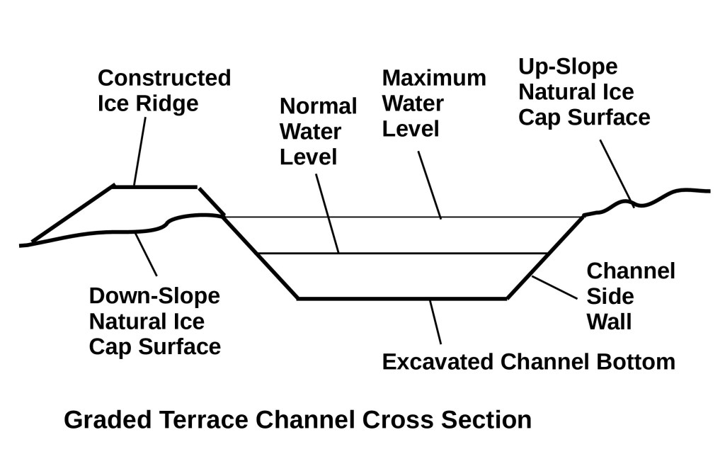
The figure below shows the cross section of an excavated channel at its terminus. The design has a bottom width of 5 m, The side walls rise at a 45 degree angle. The normal water level is 1 m. The normal cross sectional area of the stream is 6 m^2. The cross sectional area of the stream at maximum design water level is 12 m^2. This configuration gives the following values for Manning’s equation. The design slope of the channel is 1.25 m elevation drop / 1000 m along the channel.
R = 6 /(5 + 2.8) = .77 m
S = .00125
Based on this configuration the flow velocity and flow rate are as follows:
V = 2.37 m/sec
Q = 14.24 m^3/sec = 1.23 * 10^6 m^3 /day = .11 km^3 / 90 day melt season
Therefore 88 channels are required to collect 9.7 km^3 in a melt season. An additional 3.6 km^3 will flow from the natural ice sheet catchment into the lake and an additional .2 km^3 will flow from the natural ice free catchment into the lake.
In the actual construction of the melt water collection channels, each channel will terminate near the glacier edge flowing into the impounded portion of Tasersiaq Lake. Each channel will extend out from the lake toward the most distant outer edge of the collection area. North of Tasersiaq Lake a total of 50 terrace channels will extend to a point approximately 140 km north of the lake catchment. South of Tasersiaq Lake a total of 38 terrace channels will extend to a point approximately 105 km south of the lake catchment. Since each channel will follow the contours of the glacial topography the actual length of each channel will be an estimated 180 km in the north section and 140 km in the south section of terraces. Some channels may include branches in their outer reaches to improve collection efficiency. These branches, which will carry smaller quantities of water than the main channel, can have a shallower and narrower cross section and the combined cross section of all branches of a single terrace will decrease as it approaches the far end of the channel.
The size of each channel, at its terminus will be as described above. However, since water collects in the channel throughout its length, the cross section size can be smaller near the start point of the terrace and grow throughout its length. The average cross sectional throughout the length is estimated to be .65 of the cross sectional area at the terminus.
It is expected that local irregularities in the surface contour may make it necessary to excavate the channel to depths greater than predicted by the optimum size for a maximum melt day. To account for the extra ice volume excavated for this purpose it is assumed that the amount of ice excavated will be increased by a factor of 3.
Taking into account all correction factors:
Total Excavated Ice Volume per Channel =
Cross sectional area needed on average flow day *
Adjustment for maximum flow day volume *
Adjustment for reduced volume needed nearer to the beginning of the channel *
Adjustment for surface irregularities *
Actual channel length
Total Excavated Ice Volume per Channel = 6 m^2 * 2 * 0.65 * 3.0 * Actual channel length
Total Excavated Ice Volume for entire Network =
Total Excavated Ice volume in North Channel *
50 channels +
Total Excavated Ice Volume in South Channel *
38 Channels
Total Excavated Ice Volume for entire Network = 3.35 * 10^8 m^3
Citations and Links:
6. Andreas P. Ahlstrøm, Dorthe Petersen, Peter L. Langen, Michele Citterio, Jason E. Box et al, Abrupt shift in the observed runoff from the southwestern Greenland ice sheet, Sci. Adv. 2017;3: e1701169, 13 December 2017 Abrupt shift in the observed runoff from the southwestern Greenland ice sheet | Science Advances
44. USDA Forest Service, San Dimas Technology and Development Center FX3 Help (orst.edu)
